Jump to content
SAU Community

Recommended Posts

hello Friend :)

And thank you for the warm welcome .. I was however looking forward to a roundhouse kick to the face as in the other thread :yes:

Excellent....

That makes me happy in the pants!

:P

;) just dont make a mess on the floor ok. a roundhouse kick can be arranged if you wish :stupid:

hello Nikita, are thoos boobies on top of that pentagram?

every time i look it reminds me of the boob head deamon from Little nicky movie...

lol god damn lee, always thinkin of teh boobies. not that i blame you :D

its actually a heart lee if you look closer

:stupid:

bahahahahahahahahahahahaha I LOVE BOOB HEAD!

hahaa it's a heartagram .. A Love Heart and a Pentagram... :yes:

BOOB FACE AHH!

Not quite the same .. But you get the dealio! ;)

boobhead-2.jpg

OMG!!! Its Mike!!!!

OK off I go...

got do us proud *wipes tear from eye*

;) just dont make a mess on the floor ok. a roundhouse kick can be arranged if you wish :stupid:

lol god damn lee, always thinkin of teh boobies. not that i blame you :D

its actually a heart lee if you look closer

I guess the roundhouse kick would make me feel a little warm and fuzzy inside ... Almost like you guys were welcoming me into the community .. that's usually how it goes right?? :yes::P

HOLY SHIT ARE YOU REALLY CHUCK NORRIS??

I guess the roundhouse kick would make me feel a little warm and fuzzy inside ... Almost like you guys were welcoming me into the community .. that's usually how it goes right?? ;):P

HOLY SHIT ARE YOU REALLY CHUCK NORRIS??

no, but i do carry a photo of him im my wallet. it hurts to look at it, and i get a bruised eye everytime i do. feels like i'm being roundhouse kicked. it does make you feel all warm and fuzzy inside, until you realise that the roundhouse kick actually forced a hampster in through your ribcage and is now starjumps on your liver :yes:

who wants to help with the initiating *pulls out a leg resembling that of chuck norris* :stupid:

Bureau of Meteorology

Queensland Regional Office

The Standard Emergency Warning Signal should NOT be used with this message.

TOP PRIORITY FOR IMMEDIATE BROADCAST

SEVERE THUNDERSTORM WARNING - SOUTHEAST QUEENSLAND

for LARGE HAILSTONES, DAMAGING WIND, VERY HEAVY RAINFALL and FLASH FLOODING

For people in parts of the

Southeast Coast and

Eastern Darling Downs & Granite Belt Forecast Districts.

Issued at 3:58 PM Tuesday, 30 January 2007.

At 3:55 PM , Bureau of Meteorology weather radar detected severe thunderstorms near Toogoolawah, the area southwest of Esk, and the area east of Warwick. These thunderstorms are generally slow moving. Severe thunderstorms are forecast to affect northern Lake Wivenhoe by 4:25 PM and Esk, southern Lake Wivenhoe and Cunninghams Gap by 4:55 PM .

Large hailstones, damaging winds, very heavy rainfall and flash flooding are possible.

A more general severe thunderstorm warning is also current for parts of the Wide Bay & Burnett, Darling Downs & Granite Belt and Southeast Coast Forecast Districts.

The Emergency Management Queensland advises that people should:

* Move your car under cover or away from trees.

* Secure loose outdoor items.

* Avoid driving, walking or riding through flood waters.

* Seek shelter, preferably indoors and never under trees.

* Avoid using the telephone during a thunderstorm.

* Beware of fallen trees and powerlines.

* For emergency assistance contact the SES in your local government area, listed in the White Pages under either State Emergency Service or your local council.

The next warning is due to be issued by 4:55 PM.

This warning is also available through TV and Radio broadcasts, the Bureau's website at www.bom.gov.au or call 1300 659 219. The Bureau and Emergency Management Queensland would appreciate this warning being broadcast regularly.

no, but i do carry a photo of him im my wallet. it hurts to look at it, and i get a bruised eye everytime i do. feels like i'm being roundhouse kicked. it does make you feel all warm and fuzzy inside, until you realise that the roundhouse kick actually forced a hampster in through your ribcage and is now starjumps on your liver :yes:

who wants to help with the initiating *pulls out a leg resembling that of chuck norris* :stupid:

*Braces Self*

ALRIGHT GO!

But Don't f**king Shatter anything!

Bureau of Meteorology

Queensland Regional Office

The Standard Emergency Warning Signal should NOT be used with this message.

TOP PRIORITY FOR IMMEDIATE BROADCAST

SEVERE THUNDERSTORM WARNING - SOUTHEAST QUEENSLAND

for LARGE HAILSTONES, DAMAGING WIND, VERY HEAVY RAINFALL and FLASH FLOODING

For people in parts of the

Southeast Coast and

Eastern Darling Downs & Granite Belt Forecast Districts.

Issued at 3:58 PM Tuesday, 30 January 2007.

At 3:55 PM , Bureau of Meteorology weather radar detected severe thunderstorms near Toogoolawah, the area southwest of Esk, and the area east of Warwick. These thunderstorms are generally slow moving. Severe thunderstorms are forecast to affect northern Lake Wivenhoe by 4:25 PM and Esk, southern Lake Wivenhoe and Cunninghams Gap by 4:55 PM .

Large hailstones, damaging winds, very heavy rainfall and flash flooding are possible.

A more general severe thunderstorm warning is also current for parts of the Wide Bay & Burnett, Darling Downs & Granite Belt and Southeast Coast Forecast Districts.

The Emergency Management Queensland advises that people should:

* Move your car under cover or away from trees.

* Secure loose outdoor items.

* Avoid driving, walking or riding through flood waters.

* Seek shelter, preferably indoors and never under trees.

* Avoid using the telephone during a thunderstorm.

* Beware of fallen trees and powerlines.

* For emergency assistance contact the SES in your local government area, listed in the White Pages under either State Emergency Service or your local council.

The next warning is due to be issued by 4:55 PM.

This warning is also available through TV and Radio broadcasts, the Bureau's website at www.bom.gov.au or call 1300 659 219. The Bureau and Emergency Management Queensland would appreciate this warning being broadcast regularly.

Point??

its not gonna reach us... we might be lucky and actually get some water in the dam!! :stupid:

after seeing your myspace pics i think they want you to rub one out for them.

hahahah they're only human right?!?! :stupid:

Everything seemed to have gone quiet after Annas myspace photo was brought out .. I think they initiated this 'rubbing out' you speak of :yes: *giggles*

*Braces Self*

ALRIGHT GO!

But Don't f**king Shatter anything!

ok *swings artificial chuck norris leg*

*she falls to the ground screaming*

you said shatter right?

:stupid:

Bureau of Meteorology

Queensland Regional Office

The Standard Emergency Warning Signal should NOT be used with this message.

TOP PRIORITY FOR IMMEDIATE BROADCAST

SEVERE THUNDERSTORM WARNING - SOUTHEAST QUEENSLAND

for LARGE HAILSTONES, DAMAGING WIND, VERY HEAVY RAINFALL and FLASH FLOODING

For people in parts of the

Southeast Coast and

Eastern Darling Downs & Granite Belt Forecast Districts.

Issued at 3:58 PM Tuesday, 30 January 2007.

At 3:55 PM , Bureau of Meteorology weather radar detected severe thunderstorms near Toogoolawah, the area southwest of Esk, and the area east of Warwick. These thunderstorms are generally slow moving. Severe thunderstorms are forecast to affect northern Lake Wivenhoe by 4:25 PM and Esk, southern Lake Wivenhoe and Cunninghams Gap by 4:55 PM .

Large hailstones, damaging winds, very heavy rainfall and flash flooding are possible.

A more general severe thunderstorm warning is also current for parts of the Wide Bay & Burnett, Darling Downs & Granite Belt and Southeast Coast Forecast Districts.

The Emergency Management Queensland advises that people should:

* Move your car under cover or away from trees.

* Secure loose outdoor items.

* Avoid driving, walking or riding through flood waters.

* Seek shelter, preferably indoors and never under trees.

* Avoid using the telephone during a thunderstorm.

* Beware of fallen trees and powerlines.

* For emergency assistance contact the SES in your local government area, listed in the White Pages under either State Emergency Service or your local council.

The next warning is due to be issued by 4:55 PM.

This warning is also available through TV and Radio broadcasts, the Bureau's website at www.bom.gov.au or call 1300 659 219. The Bureau and Emergency Management Queensland would appreciate this warning being broadcast regularly.

thanx for that..(runs around screaming) the worlds coming to an end arghhhh!!

Guest
This topic is now closed to further replies.


  • Similar Content

  • Latest Posts

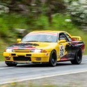
    • That was the first session so not a lot to take from the day. It was low 20s ambient and the coolant had got to 110 (and obviously had some pressure!) so that still needs to be addressed. I haven't downloaded the data yet but will. I had refilled the auto trans with Redline DT6 because it claimed the best viscosity I could find at 100o. It wasn't really long enough to get a good feel for that; while the trans got to 100o in the session it still wasn't shifting crisply as I hoped. I think I'll try a few more sessions before judging. No steering motor overheat but I'd hope not in only 1 session! But finally the suspension; it was night and day over the standard stuff and the car was a couple of seconds quicker on the same crappy tyres, which is a huge difference. I'll stick with that and get some sway bars and a mechanical diff sorted too and see how that all goes together
    • I guess it’s partially a compromise of how my car is used, wanting to be able to switch from drift to grip with track side on-car adjustment. Also partially with the way the knuckles are set there is more static camber but less dynamic camber gain. 
    • OK, so update from the track day on Friday It was a classic "an unfortunate series of events'. There were a few cars around and when i checked my mirror coming out of the fish hook I notice some smoke from the rear of mine. Looked again and it was getting much worse, I figured I'd blown a turbo or something to got off it and pulled off the racing line. However.... since it is a left hairpin into a right kink, I was on the inside of the next corner. There was a car passing me on the left and a big drop off over the ripple strip on the right......and someone had knocked the witch's hat that was on the apex about 1m onto the track. So, between those 3, I decided to mow down the cone and not damage my car/the other car. Right choice, but surprising result.  The car decided the cone was a small pedestrian so it blew the rear bonnet hinges up to protect their head in the upcoming person to car impact....I didn't see that coming and like an airbag deployment it happened super fast. Straight into the pits from there, everything was driving fine but it became clear it was a coolant leak not smoke, it was billowing up onto the windscreen. Onto the trailer and home. I'll do a separate thread about the repair (once I work out what it is ), but the immediate problem was the bonnet wouldn't open because the front was pinched onto the front bar and would not release. Ultimately we unbolted the hinge from the bonnet, pulled it back a little and it released from the front OK. "There's your problem", the top radiator hose had popped off at the radiator.
    • Yeah that looks like great caster, but I'd suggest trying less front camber some time and seeing if it helps with braking without reducing mid corner speed too much
    • I ended up setting the rear 5mm higher than normal to give some clearance.  My plan is to run the least camber I can in the rear which I think with the extra width is going to need to be -1.75 to -2.00° just to get clearance.  Guards have been rolled and pulled as much as they can/I would be wanting to.  front has the Acostal knuckle with the KPI change and the drop etc. So should be okay with the existing settings I have run with AR1s etc Front: Toe total -2mm(1mm out each side) Caster +7.5° Camber -3.8° Ackerman +15°
×
×
  • Create New...